Kharkiv MAP: resource to systematize the work of the military administration of Kharkiv region

Preconditions for creating a service
The full-scale war unleashed by the aggressor has created many challenges for everyone, including KHOVA: there is a lot of data coming from various information channels, but not all of it can be called reliable and timely.
This results in an excessive workload for the staff of the regional military administration, who are forced to structure all the information they receive, analyzing it and putting it together. The leadership of the Kharkiv Regional Military Administration requested the development of a closed mapping system to manage critical infrastructure and key aspects of the region's functioning.
This is how the WEBSPARK team created Kharkiv MAP, where we grouped this information in one place and made it available for use.
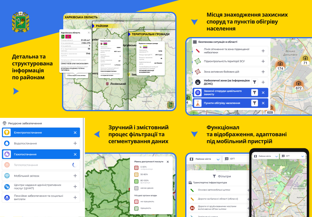
Kharkiv MAP key features
The service is one of WEBSPARK's volunteer projects. This is a visual mapping dashboard of the main indicators of the region:
- Administrative and territorial structure (region, districts, territorial communities, local governments, execution of the general fund of local budgets);
- security situation (contact line and high-risk area, territory controlled by the Armed Forces of Ukraine, active combat zone, danger zones according to the SES, civil defense facilities, heating points);
- critical infrastructure (electricity, water, gas, heat, mobile communications);
- Roads (main roads, roads on the balance sheet of the region, destroyed bridges, railways, damage to railways);
- service provision (administrative service centers, pension provision);
- social infrastructure (healthcare facilities, educational institutions, damaged buildings);
- agricultural complex (sown areas).
Cooperation with KHOVA
The regional administration kept in touch and worked with the temporarily occupied territories to always have up-to-date information to coordinate its interaction with the military. During the development process, we actively communicated with the heads of various departments: digital transformation, the State Emergency Service, utilities, education, and healthcare facilities. All of them were open to cooperation and eager to help.
Kharkiv MAP is used by department heads to see the current situation and be able to respond quickly to certain circumstances. The system was developed under the patronage of the Head of the Kharkiv Regional Military Administration and under the personal supervision of his deputy. The resource was created in a short time and launched on July 1, 2022.
How the project was developed
Kharkiv MAP is our social initiative. The resource was developed by WEBSPARK on a volunteer basis as a help to the region from the IT company and Kharkiv IT Cluster. The Cluster was the initiator and helped with the coordination between the regional authorities and the product team from WEBSPARK. The team was personally managed by CEO Yevhen Katrych:
"With the help of the developed system, it will be easier and more visible for the Kharkiv regional authorities to monitor key indicators and identify problems that require a quick response. This was especially crucial when the Ukrainian Armed Forces liberated a large part of the region and it was necessary to coordinate volunteers and ensure the delivery of humanitarian aid to the liberated territories in cities such as Kupyansk and Izium."
WEBSPARK operations
The development of Kharkiv MAP allowed the team to gain considerable experience and expertise in creating mapping services and geographic information systems that are now effectively used in various projects.
WEBSPARK continues to work with enthusiasm on a daily basis to help Ukraine and bring our victory closer and is actively involved in volunteer activities. At the same time, we have developed other important social projects, such as eTurniket and russianWarship.RIP.

Contract from a Turkish prison: How Poltava merchants circumvented Russian obstacles to trade

The Quiet Revolution on Europe’s Eastern Edge
A future without mines: How Ukraine is building a unique humanitarian demining system
